CAD Quantities with ArcGIS
I was in my garage yesterday fixing a gadget and was confronted with my workbench. It contains lots of stuff I use to fix and build things. I always set out with the idea of being organized, but as time goes along with my project "where things are" and "where things go" tends to fall to convenience rather than design, like a lot of CAD drawings. My workbench gets to a point where I need to go through every object and reorganize. In the process of going through it I discover tools I had misplaced, and left over material I can use for other projects. I sort the loose screws and hang all the tools back on the pegboard.
Using the database tools of ArcGIS on a CAD drawing can make the process of going through a CAD drawing and sorting it all out much less tedious than sorting screws.
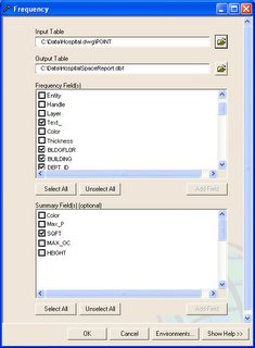
Consider the FREQUENCY command. Because ArcGIS reads a CAD file as an ArcGIS feature class, GIS tools like the FREQUENCY tool work directly on CAD drawings without conversion. The FREQUENCY tool will generate a table (report) of all of the unique occurrences of values in some table (including the virtual table of a CAD feature class). Consider this useful tool applied to the TEXT field of the AutoCAD POINTS feature class (why TEXT) that contains many different kinds of blocks and blocks with different block attribute values. If you run the FREQUENCY tool on this type of data you can expect to get useful information on the number of objects. You also have the option to sum values in fields to generate quantities of numeric values that are stored in block attributes. You can easily generate a report of all the VALVES in your water utility drawing sorted by the block attribute TYPE with the COST attribute summed in the table. To accomplish this you would run the FREQUENCY tool using the CAD POINT feature Class as input, where the FREQUENCY FIELDS are TEXT and TYPE and the SUMMARY parameter is COST.

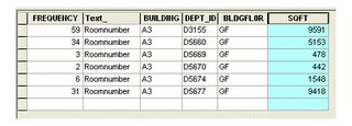
Or, consider a CAD drawing of a hospital where AutoCAD blocks in the drawing contain block attributes of the square footage of the room, the room's floor, department number and what building it is in. Using all this information we can easily generate a report of square footage by department, floor and building or combinations there of.
Using the database tools of ArcGIS on a CAD drawing can make the process of going through a CAD drawing and sorting it all out much less tedious than sorting screws.
Consider the FREQUENCY command. Because ArcGIS reads a CAD file as an ArcGIS feature class, GIS tools like the FREQUENCY tool work directly on CAD drawings without conversion. The FREQUENCY tool will generate a table (report) of all of the unique occurrences of values in some table (including the virtual table of a CAD feature class). Consider this useful tool applied to the TEXT field of the AutoCAD POINTS feature class (why TEXT) that contains many different kinds of blocks and blocks with different block attribute values. If you run the FREQUENCY tool on this type of data you can expect to get useful information on the number of objects. You also have the option to sum values in fields to generate quantities of numeric values that are stored in block attributes. You can easily generate a report of all the VALVES in your water utility drawing sorted by the block attribute TYPE with the COST attribute summed in the table. To accomplish this you would run the FREQUENCY tool using the CAD POINT feature Class as input, where the FREQUENCY FIELDS are TEXT and TYPE and the SUMMARY parameter is COST.

Or, consider a CAD drawing of a hospital where AutoCAD blocks in the drawing contain block attributes of the square footage of the room, the room's floor, department number and what building it is in. Using all this information we can easily generate a report of square footage by department, floor and building or combinations there of.


0 Comments:
Post a Comment
<< Home