Using the SELECT DATA Tool
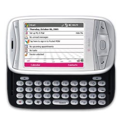 I just got my new cell phone/ pocket pc. I really look forward to how the device could simplify little parts of life. The multi-function device promises to replace my: paper shopping lists, printed bible, portable audio player, digital still camera, paper honey-do list, digital video camera, pager, daily planner, and I might even use it as a cell phone. It has four different internet connection technologies available, but I’m too cheap to pay for any of the system network options, which means if I want to upload a BLOG post with my phone I’ll have to switch coffee shops. The device has infrared data transfer capability that eliminates the need for a communication cable. My wife can give me a prioritized task list and just beam it to my phone from hers (that I can then quickly re-sort by effort level). If I do use the supplied USB data transfer cable while connected to my computer it also charges the battery. Did I mention everyone in the family got one, and they were all free! …that is to say they were free with rebates and a basic cell phone plan. The family spent time on the couch last night beaming contacts and photos between our phones… it was pretty weird.
Having a single tool certainly does have its advantages, especially if all the functions of the tool are useful or required. Because a CAD file is potentially the container of multiple ArcGIS data sets, building an ArcGIS geoprocessing tool with a single CAD file as input that then branches out to include multiple tasks with the drawing’s contents can likewise be quite useful.
The SELECT DATA geoprocessing tool allows you to select feature classes from within a feature dataset. Since a CAD file is treated as an ArcGIS feature dataset in ArcGIS this is the perfect tool to use as the first task in a model involving a CAD file from which you will use more than one of the standard CAD feature classes (POINT, POLYLINE, POLYGON, ANNOTATION, or MULTIPATCH).
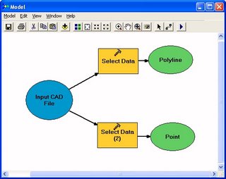 The difference between a geoprocessing model that just does something, and a geoprocessing tool, (to me) is that a geoprocessing tool has at least one exposed parameter as a variable. To enable your CAD file to be a single variable from which you access some of the POINT features and some of the POLYLINE from the drawing in some translation process, you can use the SELECT DATA tool.
posted by Don Kuehne at 1:28 PM
![]()
![]()


2 Comments:
What is the make and model of your phone as I'm looking for such a device.
Rob,
It is an MDA from T-Mobile.
Post a Comment
<< Home